Option A: City of Neighborhoods
Overview
Through the community outreach process, Oaklanders have shared that they would like more walkable neighborhoods and easy access to everyday amenities. Option A: City of Neighborhoods responds to this by proposing 18 neighborhood centers – walkable, mixed-use hubs that are designed to bring housing, services, shopping, transit access, and community life together in key locations across the City.
Neighborhood centers are envisioned as compact, vibrant places where people can live, shop, eat, and gather all within a short walk from home. While each center would have a unique local character and identity, key amenities include:
- Grocery stores, cafes, restaurants, and neighborhood services like banks, pharmacies, and cultural spaces
- A mix of multi-family housing, commercial, office, and community-service uses
- Access to public transit
- Parks, green space, plazas, shaded seating, and gathering areas
- Safe bike lanes and pedestrian paths connecting to surrounding neighborhoods
Option A seeks to strengthen Oakland’s existing assets and fill in gaps. Of the 18 proposed neighborhood centers shown in Figure 3-6, nine are enhanced centers, based around existing commercial centers and main streets—such as Temescal and the Laurel District—where new housing and infrastructure will bring additional foot traffic and a local customer base that can support businesses and transit ridership. The other nine are new centers, located in residential neighborhoods that currently lack walkable access to amenities, including North Oakland, Clawson/Dogtown, Prescott, Cleveland Heights, San Antonio, Castlemont, Lockwood/Coliseum/Rudsdale, and Elmhurst – areas of Oakland that have not historically seen much market-based investment. In both cases, the goal is to make it easier for all residents to access healthy food, services, and transportation, while reinforcing Oakland’s unique neighborhood identities.
New homes and businesses in both new and enhanced neighborhood centers would be developed through reuse of aging commercial and industrial properties. The scale of new development could range from the heights and densities of buildings in present-day Fruitvale Village to the area around Broadway-Valdez, depending on the context of surrounding neighborhoods, with taller and denser new development encouraged in more urban parts of the City. In all neighborhood centers, the highest densities would be located around central gathering places like a park or commercial area and would transition into lower density neighborhoods.
In addition, Option A proposes three new R&D districts, ranging in size from about 30 to 90 acres. As described in the previous section, “What is Included in All Options,” R&D districts are campus-sized areas that would limit new development to only uses that support R&D-related activities (i.e., technology, life sciences, the green economy, and advanced manufacturing). Option A locates new R&D areas in upper West Oakland near the Emeryville border, north Jack London (above Howard Terminal), and at the Port’s Airport Business Park (north of San Leandro Creek, across from the Martin Luther King Jr. Regional Shoreline).
By distributing new development around the City, this Option is meant to foster equitable investment and distribution of opportunities and benefits, as well as to reduce the burden of change that is placed on any one area. Policies related to phasing of implementation would guide the development of neighborhood centers so any intensification would be accompanied by the infrastructure needed to accommodate it.
Figure 3-6: Option A Concept Diagram

Figure 3-6 Key:
- Develop an R&D campus in West Oakland, which could build on the energy of a nearby R&D cluster in Emeryville
- Develop an R&D campus in north Jack London
- Attract food retailers in neighborhoods that do not have commercial centers by adding residential density
- Increase first/last mile connectivity between neighborhood centers, job hubs, and regional transit in coordination with the development of slow streets, bike infrastructure, and urban greening
- Enhance existing commercial centers in areas that are likely to redevelop by adding higher density housing and employment uses
- Add a new commercial area between the Coliseum area and Hegenberger Road that features live/work artist spaces, cultural centers, and production design and repair (PDR) businesses
- Develop an R&D campus at Port Airport Business Park
- Add new parkland and public space within neighborhood centers as central community gathering spaces
Note: This figure illustrates areas of significant change. However, all parts of the City will be affected by the General Plan.
Big Ideas
Land Use
Change Areas
The neighborhood center locations shown in Figure 3-6 were selected based on the following criteria:
- Existing commercial areas (labeled in Figure 3-6 with red stars) and identified commercial service gaps (labeled in Figure 3-6 with blue stars), with a special focus on food access gaps identified in the Environmental Justice Element;
- Concentrations of potential opportunity sites that are likely to be redeveloped; and
- Existing transit service that can connect neighborhood centers to each other, to regional transit, and to job hubs, and where there is potential for added density to support more frequent transit service.
In this Option, jobs growth beyond the baseline is focused in neighborhood centers; in a new commercial area around the Coliseum and the northern portion of Hegenberger Road that would feature live/work uses, artist spaces, and production design and repair (PDR) businesses; and in new R&D districts located on former industrial lands in West Oakland and north Jack London, and at the Port’s Airport Business Park. Employment areas were selected based on the following criteria:
- Potential for new R&D districts to support adjacent neighborhoods by phasing in cleaner uses in existing industrial areas
- Balance of distribution of employment across the City with the economic benefits of concentrating similar businesses near one another (i.e., R&D campuses)
Design
Each neighborhood center would be oriented around a community gathering space such as a plaza, park, or commercial main street. As shown in Figures 3-7, 3-8, and 3-9, higher density development would be generally concentrated at the center’s core, with density and building heights decreasing towards existing lower-density residential areas. Planning, infrastructure and economic development policies would help neighborhood centers attract amenities that are community priorities, reflect neighborhood culture, and feel welcoming to all residents.
Transportation
Option A aims to increase neighborhoods’ self-sufficiency by adding more employment and commercial uses within easy walking and biking distance from peoples’ homes. As such, supporting these connections would be the primary transportation focus for this concept. Strategies include:
- Improving first and last mile connectivity (i.e., the initial and final segments of a transit trip, such as the few blocks between home and a bus stop) between neighborhood centers and existing transit connections by adding new bicycle-friendly infrastructure (bike lanes, slow streets, and bike/scooter rental stations) and pedestrian-friendly infrastructure (well-lit sidewalks and crosswalks, wayfinding signage, and traffic calming features).
- Incorporating slow streets into circulation planning for neighborhood centers.
- Potential street closures, with the goal of creating plaza or pedestrianized public spaces in the neighborhood centers.
- Lowering traffic speeds within neighborhoods and near neighborhood centers through methods such as more frequent pedestrian crossings, “pedestrian refuge” median islands, narrower traffic lanes, slower speed limits, and other methods.
- Parking policies that focus on creating more pedestrian-friendly streets and plazas, while also ensuring that neighborhood centers remain accessible to people who are traveling by car.
These new features would make it easier to walk and bike between neighborhood centers and surrounding residential areas and would also connect more people to existing transit that connects neighborhood centers and regional destinations, like Downtown and the new job hubs.
Parks and Conservation
The key parks strategy in this Option is to look for opportunities to provide each neighborhood center with a community park at least 10 acres in size (i.e., the size of San Antonio Park), though additional smaller “pocket parks” and plazas would be required in new developments as well. Some proposed neighborhood centers have existing parks – these would see improvements or expansions to accommodate the increased use from additional density. Other neighborhood centers do not currently have a central park. These areas would add new green space by redeveloping potential opportunity sites into new parks, but not at the expense of displacement. Policy for how new parks will be acquired, developed, and maintained will be developed as part of the OSCAR and future Parks Master Plan.
Figure 3-7: Detail of Enhanced Neighborhood Center (Fruitvale)
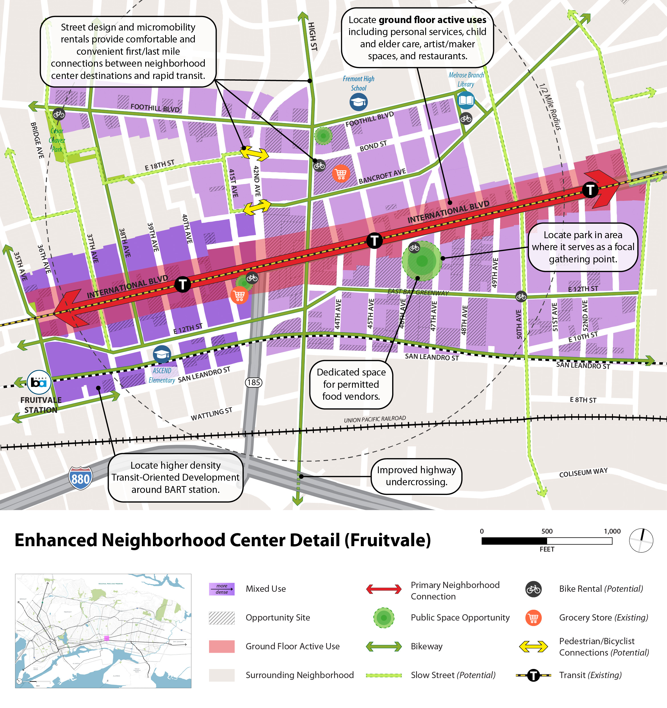
Figure 3-8: Detail of New Neighborhood Center (Eastmont)
Figure 3-9: Illustration of Potential Enhanced Neighborhood Center (Laurel District) Existing: 39th Ave at MacArthur Blvd, early summer 2025, looking northwest

Fig 3-9 Key:
- Centrally located park includes seating, play and exercise equipment, public restrooms, and programs for youth, families, and seniors
- Residential buildings are oriented towards the park
- Densest housing (average of 188 units/acre, with buildings up to nine stories tall) is focused around a community gathering space and healthy food access
- Planning and economic development policies attract amenities that are community priorities, such as healthy food retailers
- Sidewalk bulbouts, raised crosswalks, bus stop improvements (bus shelter, route signage, lighting, bicycle parking) and other traffic calming features increase safety and comfort for traveling throughout neighborhood centers without a car
- Commercial main streets connect to citywide network of slow streets and bikeways
- Public art is incorporated in new development
Figure 3-10: Illustration of Potential R&D District (West Oakland)
Fig 3-10 Key:
- The West Oakland Link, an MTC-led pedestrian/bicycle pathway that will allow for direct pedestrian/bicycle travel between Downtown Oakland and Downtown San Francisco, is completed
- Existing live/work artist housing is preserved
- Planning and economic development policies support new research and development (R&D) uses, as outlined in the West Oakland Specific Plan
- Increased tree canopy and sidewalk plantings support cooler urban temperatures, stormwater management, biodiversity, and air quality
- Signage about local history and culture is added to the Mandela Parkway
Buildout
Option A buildout would result in 83,490 new housing units and 109,110 new jobs. These estimates include the shared growth that is expected to occur across all three Options. Figures 3-11 and 3-12 display heat maps showing where overall housing and jobs growth will take place in Option A.
Chart 3-1: Jobs Growth by Sector (Option A)
Chart 3-2: New Jobs and Housing by Zip Code (Option A)
Chart 3-3: New Jobs and Housing by PDA (Option A)
Figure 3-11: Option A Housing Growth(PDF, 10MB)
Figure 3-12: Option A Jobs Growth(PDF, 9MB)
Reflection Questions: Which features of Option A do you like or dislike? Overall, how much do you support Option A?
Back to Top
Continue to Option B