Chapter 3, Oakland for All: Options for How We Stabilize and Grow
Table of Contents
Every Option for How We Stabilize and Grow is assumed to build upon a hypothetical “baseline” Oakland in 2045. This starting point reflects implementation of the actions, policies, and improvements identified in current adopted plans —including Phase 1 elements of the General Plan Update—as well as completion of current pipeline development and capital improvement projects. This baseline does not represent an Option in and of itself, because it does not generate sufficient development to meet Oakland’s jobs and housing projections. Rather, each Option adds additional density and improvements to the baseline starting point to create a different comprehensive vision for the City that meets projected growth demands. Features that are shared across Options are shown in Figure 3-1 and described in greater detail in this section.
All three Options include a shared amount of projected housing and jobs growth coming from four sources, described below. The locations of shared housing and jobs growth are shown in Figure 3-2 and Figure 3-3.
- Pipeline Projects. The growth projections presented for each Option include projects that are currently under review or are in the process of being developed. It is assumed that planned development today will be part of the City’s landscape tomorrow, and so additional growth projections should include these projects. Planned development also provides insight into current market conditions, which helps the planning team make more informed estimates about what types of new development can be expected to be built under different zoning conditions. As of December 2024, there were 99 major projects in the development pipeline (i.e., with a building permit or active planning permit), which are collectively expected to add about 8,400 new housing units and about 4,180 new jobs.
- Housing Element Sites and Accessory Dwelling Units. Oakland’s 6th Cycle 2023-2031 Housing Element established housing goals, policies and an action plan for developing 26,000 new housing units across varying income levels over the next eight years. Excluding pipeline development (counted above) and other Housing Element sites downtown (counted below), implementation of the Housing Element alone would contribute to 13,670 housing units and 5,440 Accessory Dwelling Units (ADUs), for a total of just over 19,110 units.
- Downtown Development. Oakland’s most recent specific plan, the Downtown Oakland Specific Plan (DOSP, adopted in 2024), outlines an ambitious plan for a substantial amount of new housing and jobs growth in Downtown Oakland and Jack London. To be conservative with growth projections and to ensure the growth projected for the GPU’s planning horizon Citywide actually occurs across the City, rather than entirely concentrated in the Downtown, the GPU assumes a smaller proportion of this growth will occur on opportunity sites identified in the DOSP during this time period– approximately 27,125 housing units and 23,360 jobs. These assumptions are based on densities/intensities of recently completed and pipeline projects in the Downtown.
- Other Shared Growth in All Options. A certain amount of growth will occur in areas outside of those that have been identified for specific changes in the three Options. This shared growth may occur on currently vacant or underutilized sites that do not require any changes to land use to develop.
Figure 3-1: Features Included in All Options (2045 Baseline)
Figure 3-1 Key:
- West Oakland Link
- Commercial and production uses around Prescott Market
- High density and tall buildings are allowed around select BART stations
- High density and tall buildings are allowed around select major transit corridors
- Howard Terminal redeveloped with greener, electrified uses that serve the Port of Oakland
- Buildout of the Downtown Oakland Specific Plan, Broadway Valdez Specific Plan, and Lake Merritt Station Area Specific Plan
- Brooklyn Basin (full buildout)
- Existing neighborhood commercial centers continue to serve their neighborhoods
- 42nd Avenue is extended, replacing the diagonal portion of Alameda Avenue
- Industrial land is modernized to reduce pollution and provide more jobs
- Transit frequency improvements identified in AC Transit’s Major Corridors Study are completed
- Buildout of Coliseum Area Specific Plan
- Street grid improvements
- Oak Knoll (full buildout)
- Industrial land is modernized to reduce pollution and provide more jobs
- San Leandro Creek greenway
- East Bay Greenway
Note: This figure illustrates areas of significant change. However, all parts of the City will be affected by the General Plan.
Figure 3-2: Shared Housing Growth(PDF, 4MB)
Figure 3-3: Shared Jobs Growth(PDF, 4MB)
Land Use
- Land use and development assumptions for 2045 in all three Options reflect the completed buildout of Oakland’s current pipeline of major development projects, Housing Element sites, new ADUs, Downtown development resulting from the DOSP, and general Citywide growth (see “Shared Growth”).
- Downtown’s identity as Oakland’s central office, commercial and cultural employment hub will be reinforced in accordance with the DOSP, with significant residential and employment growth in this area. As described in the Parks and Open Space section below, Downtown development will also include parks and open spaces.
- Outside of Downtown, new development is expected to occur along Oakland’s major transportation corridors and transit hubs that are zoned for high density and tall (six- or more story) buildings, including: International Boulevard, MacArthur Boulevard between Fruitvale Avenue and High Street, Telegraph Avenue, Broadway, College Avenue, San Pablo Avenue, Grand Avenue, Hegenberger Road, and the West Oakland, Lake Merritt, Coliseum, and Rockridge BART station areas. Within Downtown, growth is assumed around the 12th and 19th Street BART stations. Resulting development will include commercial, office, and residential uses, including some as mixed-use development (often in the form of commercial on the ground floor and housing units on the floors above).
- Residential neighborhoods are expected to gradually become denser, as additional multi-unit housing types (two-, three-, four-, and five- or more unit structures) replace or are added to single-unit structures over time, as allowed by already-adopted City policies and State laws. Housing and development will follow the no-net loss to open and green space policies laid out in the prior iterations of Oakland city documents. As neighborhoods become denser, there will be more community need for easily accessible, safe public open spaces.
- Residential neighborhoods will gradually become more “complete communities” due to policy direction in the LUTE that will allow neighborhood-serving commercial uses (i.e., corner grocery stores, cafés, day cares, home businesses.). This plan will also need to serve non-profits and community-based entities that provide essential services to the community (seniors, youth, unhoused, permanent supportive housing). These services located in residential areas, will create more destinations where people can walk to meet their daily needs.
- Limited additional development beyond the currently approved pipeline of projects will occur in environmental hazard zones (i.e., fire hazard severity zones, floodplains), so as to mitigate against extreme weather events and changing environmental conditions due to climate change.
Employment
- Downtown will continue to serve as the primary hub for office, commercial and cultural employment.
- Land use designations in areas surrounding Oakland’s major employers, including the Port of Oakland and existing major healthcare providers, will support the growth of Oakland’s key economic sectors.
- Key neighborhood commercial areas and main streets will continue to serve their neighborhoods.
- Industrial areas will be modernized to support cleaner, jobs-dense industries (i.e., sectors that provide many jobs in relation to the amount of land used). The City aims to attract growing sectors like technology, life sciences, the green economy, and advanced manufacturing, known broadly as R&D. One of the goals of the LUTE is to designate some existing industrial areas specifically for R&D uses. Prioritizing these activities will help maximize limited industrial space, create more jobs, and reduce pollution. The Options propose different possible locations and amounts of new R&D uses.
- The Coliseum area is planned to be a major mixed-use employment and entertainment center, consistent with the vision outlined in the Coliseum Area Specific Plan.
Transportation
- Transit improvement projects identified in AC Transit’s Major Corridors Study (2016) will be completed. These include more frequent bus service along: MacArthur Boulevard, West Grand Avenue, San Pablo Avenue, Telegraph Avenue, Broadway, College Avenue, Foothill Boulevard, Bancroft Avenue, and Fruitvale Avenue south of San Leandro Street.
- Transit operation and street safety improvements identified in OakDOT’s 2020 Transit Action Strategy will be completed.
- Improvements such as parks, art, lighting enhancements, and land use activations at freeway undercrossings described in the Planning Code’s Freeway Zoning will be completed, including specific improvements identified in the DOSP.
- Ongoing local transportation improvements identified in the Alameda County Transportation Commission (ACTC) Comprehensive Investment Plan will be completed.
- Ongoing buildout of bicycle and pedestrian infrastructure and priority projects identified in the City of Oakland’s Bicycle Plan, Pedestrian Plan, Paving Plan, and ADA Transition Plan will be completed.
- Ongoing buildout of existing and proposed bike paths (per the current OakDOT bikeways dataset) will be completed as greenways. Greenways are generally defined as linear paths designed for bicycle and pedestrian use that involve an environmental component (i.e., a natural setting, tree canopy coverage, green stormwater infrastructure, or linear park features).
- The East Bay Greenway, a 30-mile-long facility connecting from Oakland to Fremont, linking between BART stations with a series of trails and protected bikeways, will be completed. In Oakland, the bike path will run underneath and parallel with the BART right of way between the Lake Merritt station and the San Leandro border.
- The West Oakland Link, a 1.1-mile-long elevated pedestrian and bicycle pathway that will connect Mandela Parkway with the existing San Francisco-Oakland Bay Bridge East Span path, will be completed.
- The Oakland/Alameda Access Project, an infrastructural renovation of the Webster and Posey tubes where they connect to I-880, will be completed. The project aims to reduce intercity cut-through traffic on neighborhood streets in Jack London and enhance bicycle and pedestrian connectivity between Alameda and Oakland.
- The LUTE will include realignment and construction of new streets in Victory Court.
- The LUTE will include realignment and construction of new streets in the Central Estuary, including extending 42nd Avenue to phase out the diagonal portion of Alameda Avenue (described in further detail in Option C).
- The LUTE will include realignment and construction of new streets north of San Leandro Street, between 77th and 98th Avenues, where the street grid is currently lacking (shown in Figure 3-4).
Figure 3-4: Detail Diagram of East Oakland Street Grid Realignments
Parks and Open Space
- Shoreline adaptation and park projects will include improvements identified in the DOSP, including improvements to the Channel Estuary Park. The Lake Merritt loop greenway, linking Downtown, Chinatown, and West Oakland, will be completed.
- The General Plan will be aligned with the shoreline adaptation policies and projects to be identified by the Oakland Alameda Adaptation Committee, Oakland’s Sub-Regional Shoreline Adaptation Plan, and the Port of Oakland, which focus on enhancing public access to the water and shoreline while protecting low-lying communities from coastal flood risk.
- In flatland communities that face high levels of pollution, environmental injustice and/or socioeconomic disadvantage, there will be a significant increase in citywide urban tree canopy planting and maintenance. The GPU will also focus on park safety and restoration in these neighborhoods.
- The lower reaches of San Leandro Creek will be restored, as identified by the Alameda County Public Works Department and the San Francisco Bay Restoration Authority.[1] The General Plan would formalize and strengthen the City’s support for restoration and activation of San Leandro Creek to provide greenway connectivity throughout the Sobrante Park and Brookfield Village neighborhoods, as shown in Figure 3-5.
- There will be continued collaboration between the Oakland Parks, Recreation and Youth Development (OPRYD), and Public Works Projects and Grants Management team. OPRYD will create a Parks Master Plan that will guide parks and open space development.
- The Parks Master Plan will align with Oakland’s existing environmental justice and equity mandates. These include but are not limited to: No net loss of open space, commercial and residential development that includes a 10 minute walk to parks and open spaces and creation of new open spaces/parks in instances where displacement will not occur.
Figure 3-5: Illustration of Potential San Leandro Creek Greenway
Existing: San Leandro Creek, early summer 2025, looking east from Hegenberger Road towards Brookfield Village
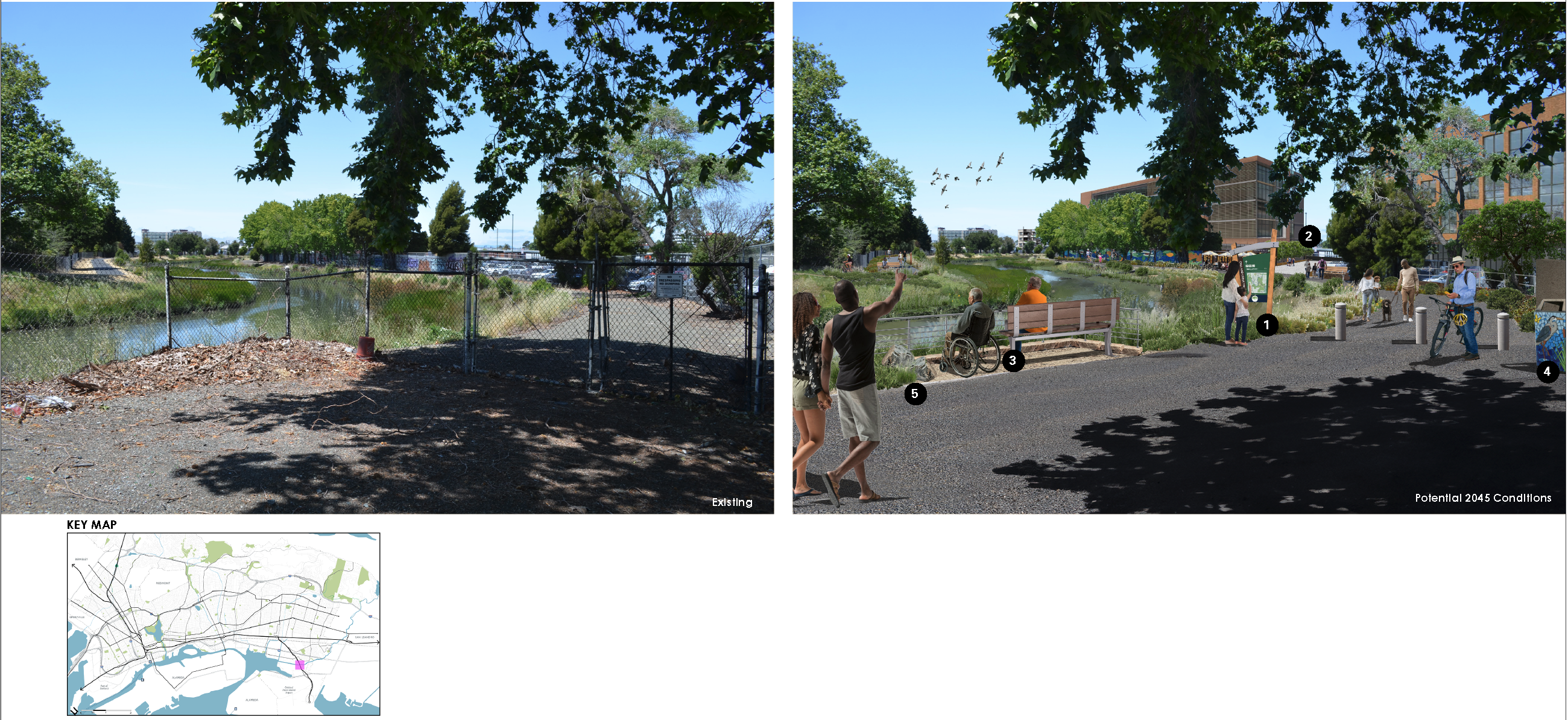
Figure 3-5 Key:
- Wayfinding and educational signage provide information about the creek’s ecology, history, and relationship to surrounding communities at key points along the greenway
- Public access to the creek greenway
- Accessible places for rest and observation along the trail
- Opportunities for public art in trail infrastructure (utility boxes, waste bins, signage, benches)
- Permeable pavement and native planting support water quality
Shared Policy Actions
In addition to the physical changes described above, each Option will also rely on supportive policy and zoning actions that will be further developed later in the planning process, including:
- Streamlined development permitting and application process
- City technical and financial support for affordable housing development and community land trusts (CLTs) (described in further detail in the Housing Element)
- Exploration of opportunities for co-location/joint-use of public facilities
- Anti-displacement strategies and other policies grounded in improving social and racial equity
- Development of Citywide biodiversity goals
- Parkland acreage standards, maintenance and funding strategies
Incorporating community ideas and solutions into the programs mentioned above will be critical to ensure the long-term sustainability and effectiveness of policy strategies.
Reflection Questions: Which features and ideas in the baseline are you most excited about? Are there any planned improvements that should be included that we missed?
Back to Top
Continue to Option A
Footnotes
[1] https://www.acpwa.org/projects/2021/San-Leandro-Creek-Trail/San-Leandro-Creek-Trail.page https://www.sfbayrestore.org/projects/san-leandro-lisjan-creek-community-project